LOCATION

Ukraine was an industrial center of the former Soviet Union. The capital city of Kyiv (Kiev) was reorganized as an ideal industrial socialist city with up to 25% of its city areas transformed into highly productive industrial zones. Today these ex-industrial areas are experiencing transformation.
scheme: the reconstruction of Kyiv the masterplan of 1936 by Anastasiya Ponomaryova
scheme: the reconstruction of Kyiv the masterplan of 1936 by Anastasiya Ponomaryova
Catalysts for the development
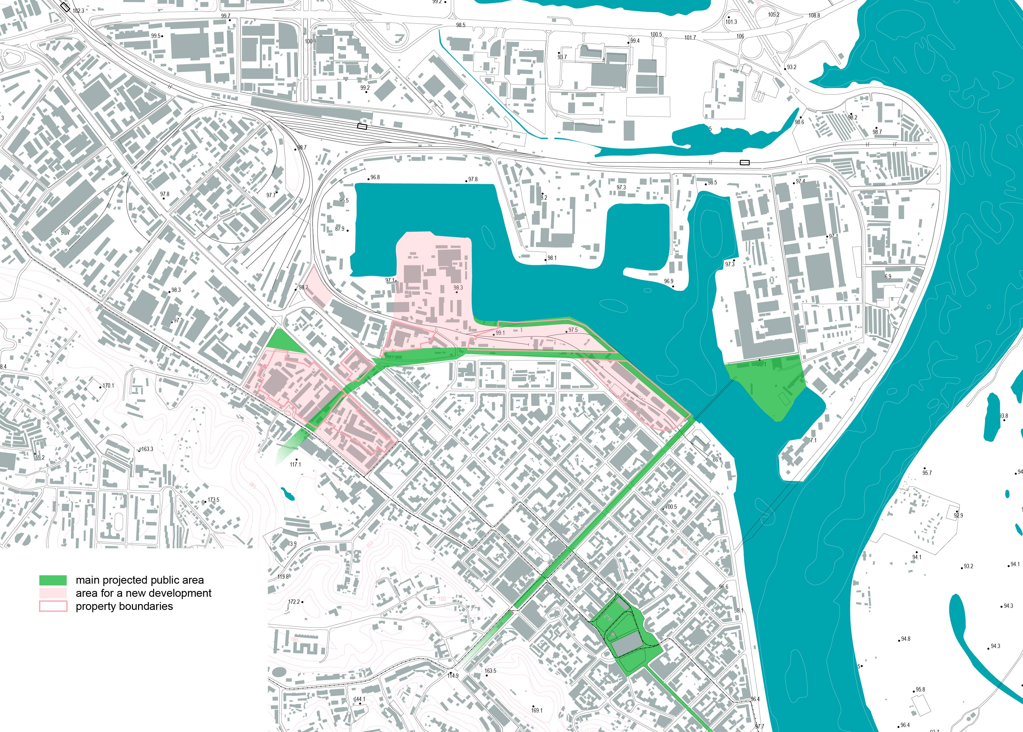
For the detailed work the next area is selected. The historical part of Podil industrial district, which includes river shore and (post)industrial quarters embracing the Old Podil.
scheme by Anastasiya Ponomaryova
scheme by Anastasiya Ponomaryova
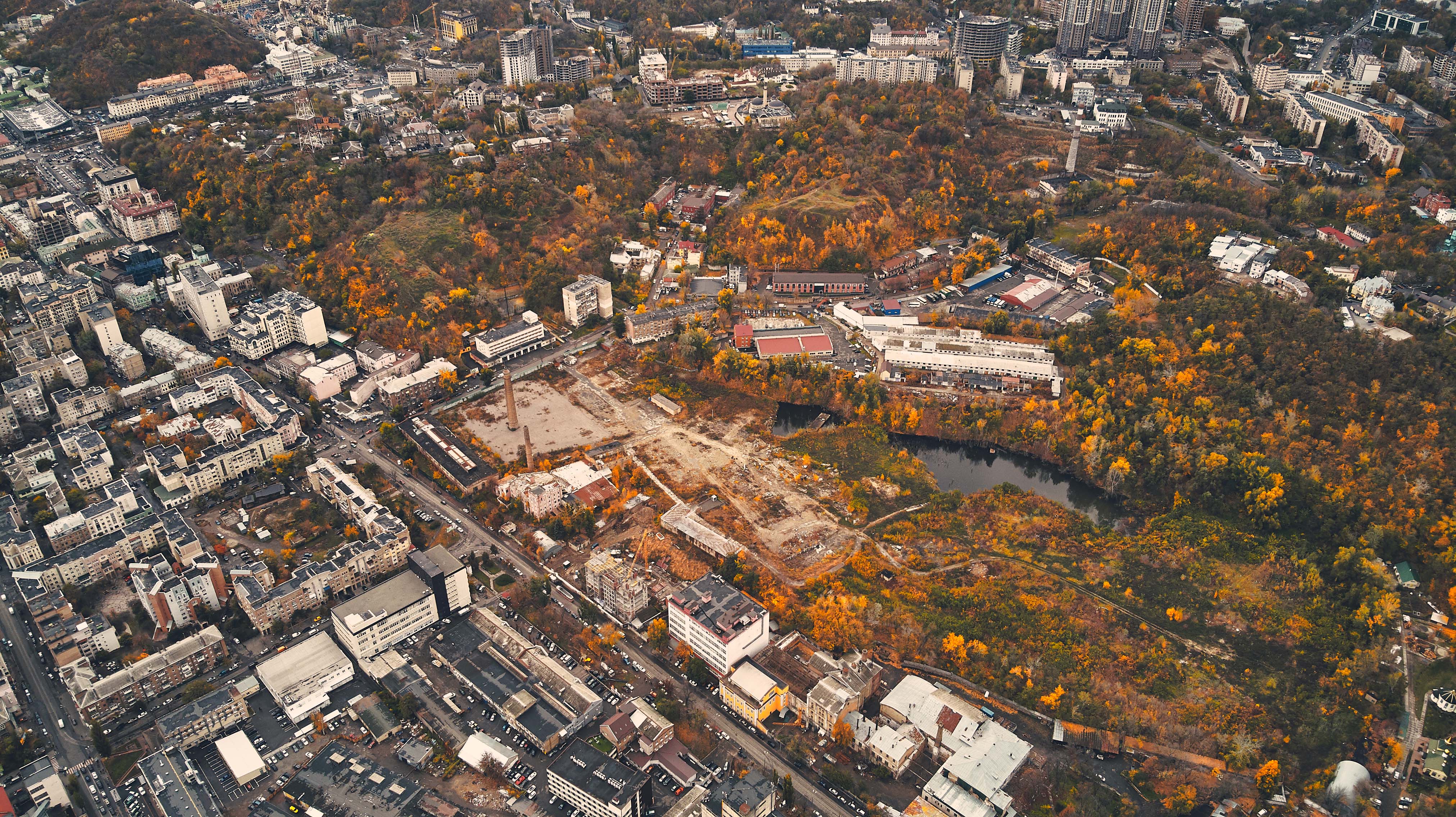
PHOTOS


GOAL
- to define scenarios for area development which incorporate design strategy and analysis of local conditions and resources
-
to start to establish/contribute to an establishing a new for Ukraine paradigm for area development (disseminate an emerging paradigm for area development which is new for Ukraine)
REQUIREMENTS
- main stakeholders is private sector (developer) which initiates the project
- the developer “balances” within uncertainty and unstable political and economical environment
- there is a need in a critique of conventional standards for development. new scenarios should be proposed. the studio should contribute to establishing a new paradigm for area development
- local challenges and resources should be taken into account
- establish to a revitalization and avoid gentrification
- take into account researches and projects realized on the area
HISTORY OF THE AREA
HOW DOES THE LARGEST KYIV INDUSTRIAL DISTRICT BEGIN?
the beg. and end of the XIXth
Contemporary urban fabric of Podil started to shape according to the Kyiv masterplan, developed by Melenskyi and Geste in 1820s. Melenskyi was the city architect at that time. The plan was giving fishermen and carpenters permissions to build on the “Second” part of Podil, near Ploskyi (transl. flat; historical name of the area to the north from Kontraktova Sq.) as they depended highly of the river access.
Environmental context: at the first glimpse one can say that Dnipro plays a critical role in shaping of Podil’s urban fabric, however it’s not the only one. On the opposite side of the area there is another natural border, the Kyiv hill, particularly Yurkovytsya hill.
While Dnipro riverside was filled with elings and fishing boats, the hill played a critical role in formation of Podils’ main industrial street, Kyrylivska St. The street while trimming the district underneath the hill became the strip mall for number of private factories which used the hill as the main clay resources for their production.
 Part of the Kyiv plan, developed by Geste (source: Architecture of Ukraine. Academy of Architecture in Soviet Ukraine)
Among the most famous are Josafat Andrzejowski Tile and Majolica Factory, founded in 1879, partly is still there. It’s remnants can be found by the address 64, Kyrylivska St. The factory was known for its tiles and variety of building decorations. At least three other factories emerged along Kyrylivska St. during the 19th century, including Brewery on the corner of Kyrylivska and Nyzhnyoyurkivska and two others by the address 35 and 54 Kyrylivska St. (pic. 1)
Contrary to the area along the riverside, which has gone through dramatic transformation during the 20th century, Kyrylivska St. retains its urban character as it used to from its foundation.
Contrary to the area along the riverside, which has gone through dramatic transformation during the 20th century, Kyrylivska St. retains its urban character as it used to from its foundation.
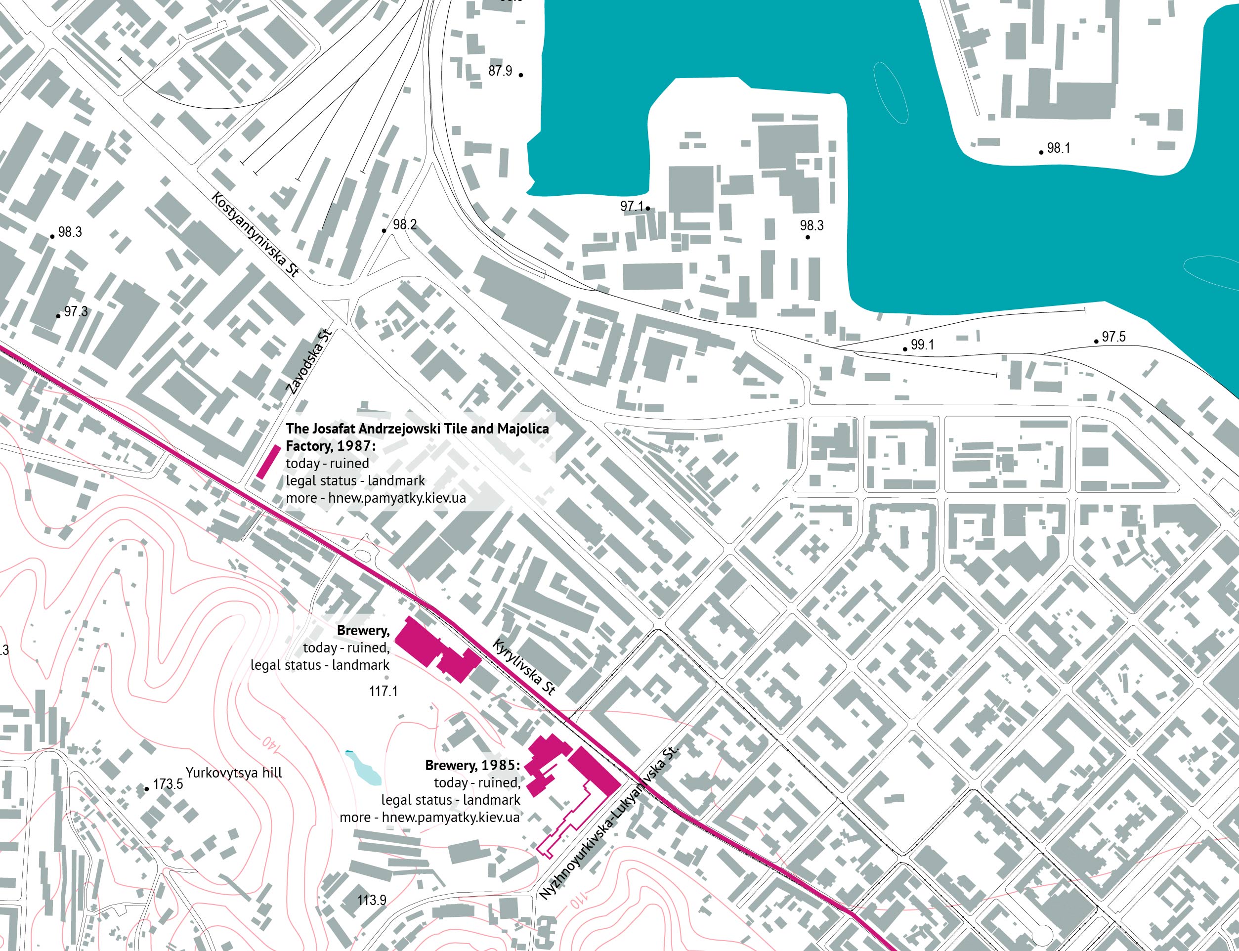 pic.1 - historical and architectural landmarks from the end of XIX on Kyrylivsk st.


Many historians argue that Kyrylivska St became the main industrial focal point during the late 19th and early 20th century.
Construction oriented industry was joined by food production like mills and refineries. This was supported by development of river transportation.
Construction oriented industry was joined by food production like mills and refineries. This was supported by development of river transportation.
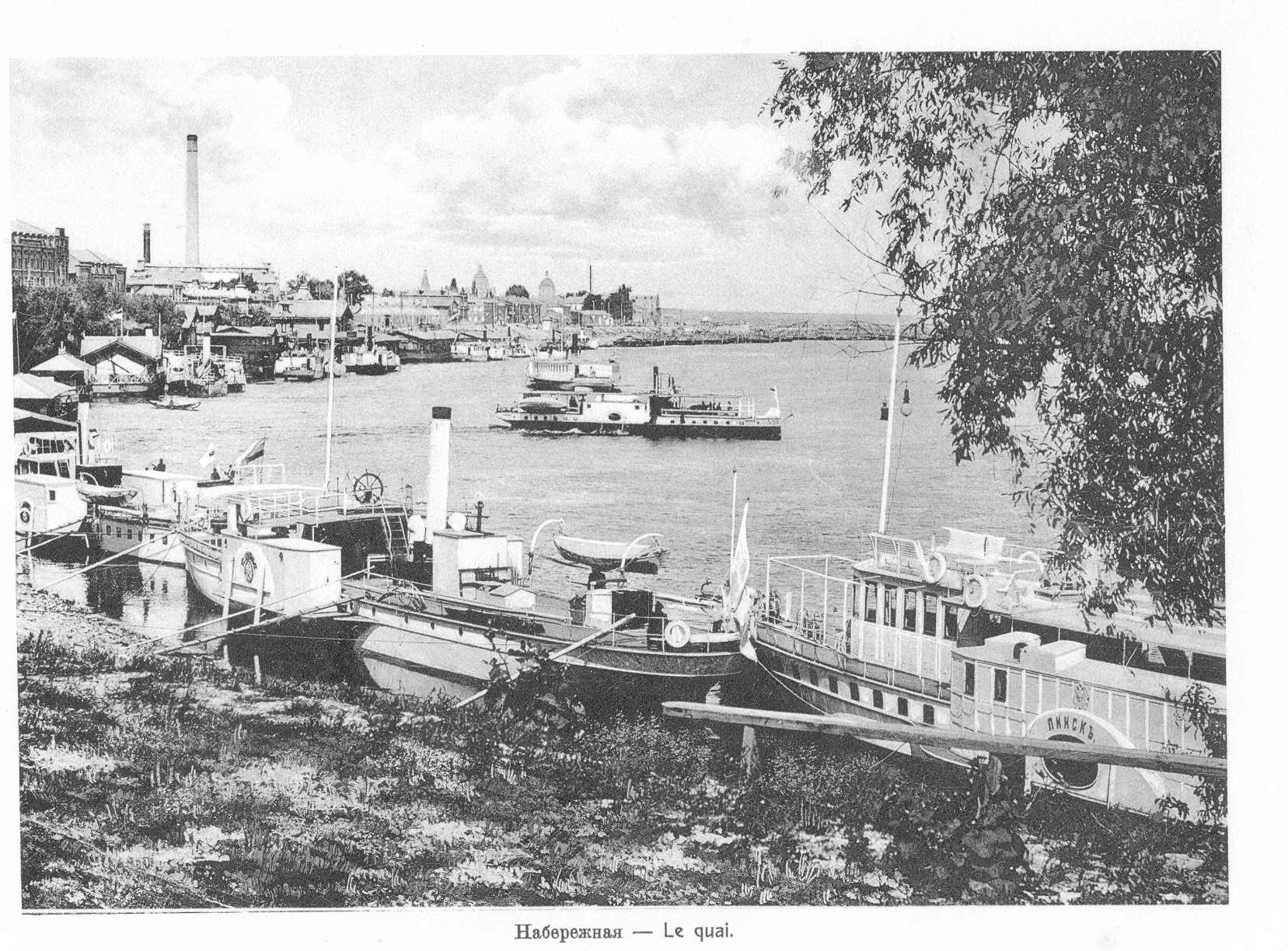
construction of Kyiv Bay, 1899
Kyiv Bay was a massive project, which took about 25 year to construct. The project forseed a massive land expansion, increasing the docking line with more than 300 units capacity. This should have make it one of the biggest as historians claim.
The project was finished in 1899 and one year later a giant obelisk was erected to commemorate this achievement. Unfortunately the obelisk has not survived to nowadays.

Project of Kyiv Harbor by Markimovich.
the very first Soviet master plan
In 3 decades after finishing of Kyiv Bay a team of soviet urban designers explored the city industrial areas for the Kyiv Master Plan 1935. Among nine industrial districts Petrivsko-Kurenivskyy district and Priorka district together had the largest number of industrial enterprises, 51 in total, occupying 128 hectares of industry (extract from the explanatory report for Master Plan for Reconstruction in Kyiv of 1936. Source: Central State Archive and Museum of Literature and Art of Ukraine). According to the new master plan (1936) this district was envisioned to occupy 378 hectares, becoming the second-largest district on the Right Bank, and third largest district in the city.
In 3 decades after finishing of Kyiv Bay a team of soviet urban designers explored the city industrial areas for the Kyiv Master Plan 1935. Among nine industrial districts Petrivsko-Kurenivskyy district and Priorka district together had the largest number of industrial enterprises, 51 in total, occupying 128 hectares of industry (extract from the explanatory report for Master Plan for Reconstruction in Kyiv of 1936. Source: Central State Archive and Museum of Literature and Art of Ukraine). According to the new master plan (1936) this district was envisioned to occupy 378 hectares, becoming the second-largest district on the Right Bank, and third largest district in the city.

The fragment from Master Plan for Reconstruction in Kyiv of 1936
The drawings that comprised the 1936 master plan contained several area plans showing projected urban development for selected city districts. Among others it included a general plan for the reconstruction of the Petrivsko-Kurenivskyy District, with a river port reconstruction project as a subarea.
![]() Project for Kyiv Port, as a part of Master Plan for Reconstruction in Kyiv of 1936. Source: Central State Archive and Museum of Literature and Art of Ukraine
Project for Kyiv Port, as a part of Master Plan for Reconstruction in Kyiv of 1936. Source: Central State Archive and Museum of Literature and Art of Ukraine
 Project for Kyiv Port, as a part of Master Plan for Reconstruction in Kyiv of 1936. Source: Central State Archive and Museum of Literature and Art of Ukraine

Project for Petrivsko-Kurenivskyy District, as a part of Master Plan for Reconstruction in Kyiv of 1936
This area, formerly a mixed-use residential, commercial, and industrial, was planned to be reorganized along segregated land-use patterns. The plan for the district reconstruction envisaged a functional division of the entire territory into certain zones, particularly: an main industrial zone, a railway transportation zone, a cultural services network, and “orderly” greenfield sites with water spaces. According to this plan, the industrial zone was to be concentrated along Kyrylivska St. up to the intersection with a railroad. These industries were separated from residential areas by a railroad on a dam, which also protected this low-lying area from floods. The territory including Petrivka with the port along the Rybalsky Peninsula and Kurenivka, was planned to be the main industrial core of the district.
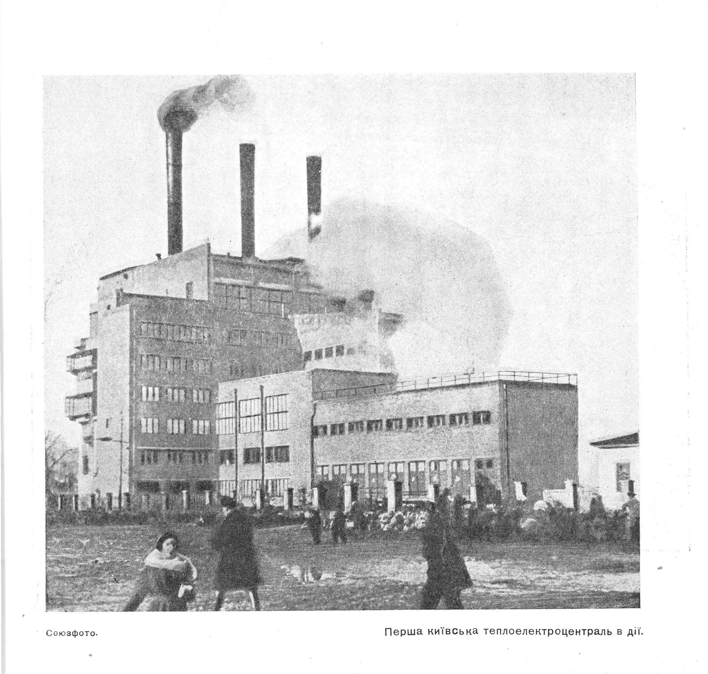 the first Kyiv power station
the master plan for 2020
Today, according to current master plan of Kyiv, the Podilsko-Kurenivskyy district (which includes a former territory of Petrivsko-Kurenivskyy) is the biggest industrial district in Kyiv, occupying 782 hectares.
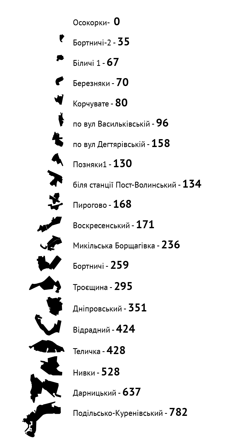
industrial areas and its ha in accord to the master plan for Kyiv development for 2020 scheme by N.Ponomaryova)
RELEVANT STUDIES
Extract from Sociological study by CEDOS and Хмарачос
The population of Podil Administrative District in Kyiv comprises around 201 000 residents. This big district combines various historically shaped neighborhoods. One of them is the area called “historical Podil” near the Dipro River. Local historical background suggests a high potential for emergence of local community in the area.
In recent years the area was thriving with numerous new local public initiatives and civil society emergence in general. They are mostly focused on the neighborhood development, fostering local community and identity. Moreover, the city administration initiated couple of big scale urban projects, particularly Kontraktova square reconstruction, as well as making of pedestrian areas.
Research Questions
The main questions are:
- Is there a micro-community in the area capable of collective actions for common interests promotion?
- Do locals identify themselves as a distinctive community, and do they consider themselves a part of a broader community of Podil District?
- Is there a single community or these are multiple ones?

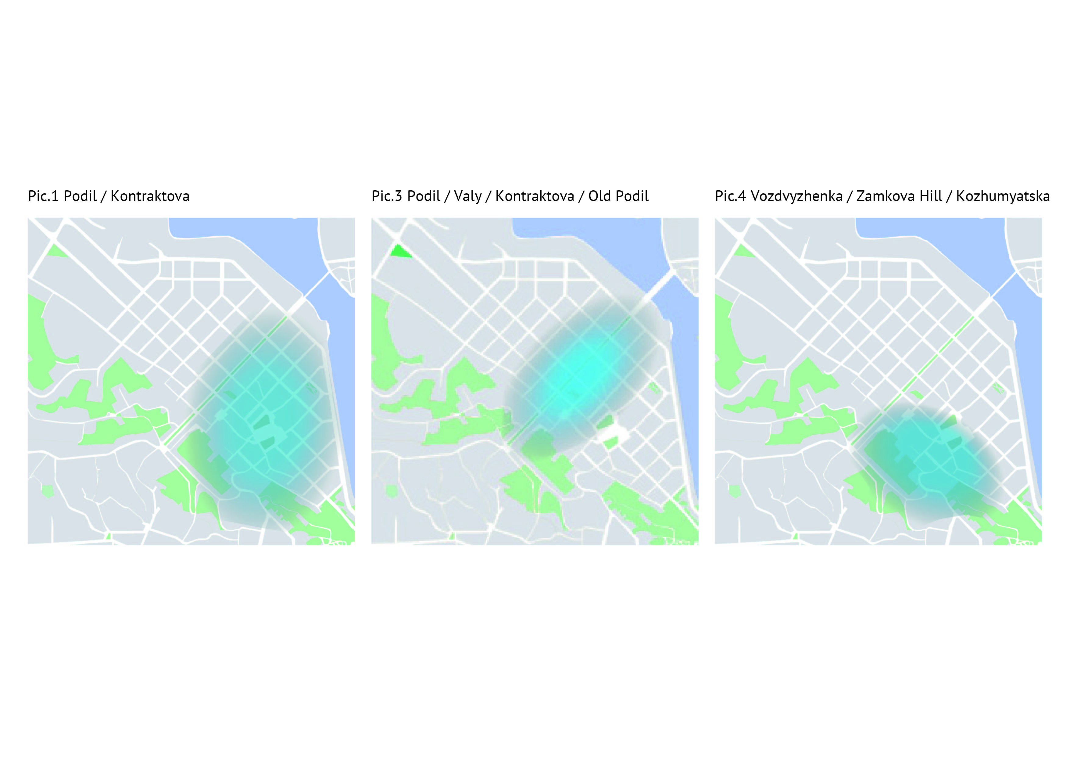
4 distinctive areas
According to the research results, most of Podil local residents view their neighborhood as a single unit. “Their neighborhood” lays within the area of “historical Podil”, limited by Zavodska St. on the north, Poshtova Sq. on the south, Dnipro river on the east and Nyzhnoyurkivska-Lukyanivska St. in the west.
The analysis results show 4 distinctive areas of respondents’ local self identification at Podil. those areas are:
The analysis results show 4 distinctive areas of respondents’ local self identification at Podil. those areas are:
- The area between Poshtova Sq., Schekavytska St. Dnipro River and Zamkova Hill. Among the most common local naming were “Podil / Kontraktova” (Pic. 1);
- The area limited by Kontraktova Sq., Spaska St., Zavodska St. and Dnopro River. Common local namiings are “Podil / Valy () / Kontraktova Sq. / Old Podil” (Pic. 2); Note: the project site lay within this area.
- The area between Schekavytska and Spaska St. along the streets of Verkhniy (upper) Val and Nyzhniy (lower) Val Streets. Common names are “Podil / Valy Kontraktova Square / Old Podil” (Pic. 3);
- The area limited by Zamkova Hill, Sahaydachnoho St. Kostyantynivska St. Kontraktova Sq. and Nyzhniy (lower) Val St. The most common nammings are “Vozdvyzhenka / Zamkova Hill / Kozhumyatska” (Pic. 4).
 Pic.2 Podil / “Tarasa Shevchenko ”subway /
Old Podil
Important to note, that these area limits are conditional, because respondents have been marking them quite approximately, not as defined borderlines of “their” neighborhood.
 Pic.1,3,4
An extract from survey
When speaking about the neighborhood you live in, please draw the area which you consider as “yours”, where you feel comfortable (without a reference to the official administrative district division).
- What is the most common name for this area?
- Imagine a person that lives in Podil District asks you a question: “Where in Podil District do you live?”, what would be your answer?